Mountain tour · Summer
Rinnenspitze 3003 m
A 3000-metre peak on the doorstep
- Duration
- 3 h
- Distance
- 3.5 km
- Ascent
- 870 mDescent 20 m
- Highest point
- 3000 mfrom 2150 m
- Difficulty
- Trail T3SAC hiking scale (Franz-Senn-Hütte – Abzweigung Höhenweg)
- Start / finish
- Franz-Senn-HütteFinish: Rinnenspitze
Route points: Franz-Senn-Hütte 0,0 km, 2150 m – Abzweigung Höhenweg 0,5 km, 2200 m – Abzweigung Rinnensee Rinnenspitze 2,6 km, 2620 m – Rinnenspitze 3,5 km, 3000 m
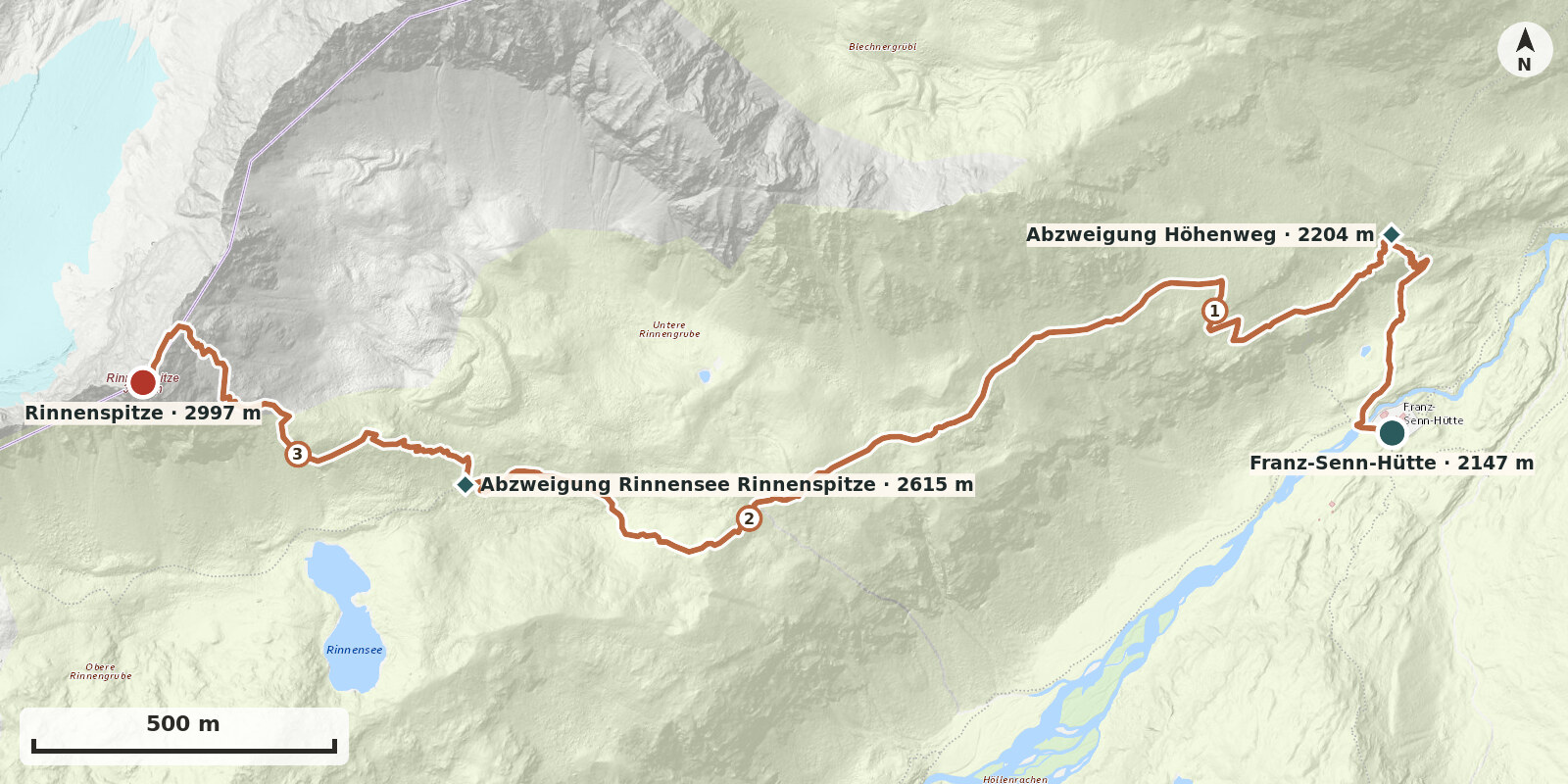
Rinnenspitze is the most popular mountain tour from the Franz-Senn-Hütte and, for many, their first 3000-metre peak: a marked path leads to just below the summit block, then an east ridge made easier by steel cables, and at the top a superb all-round view across the Lüsener Ferner to the Lüsener Fernerkogel, across to Ruderhofspitze and the Alpeiner Ferner, and down to the idyllic Rinnensee. There is no contact with the glacier, but sure-footedness and a head for heights are essential.
Route description
-
Franz-Senn-Hütte → Abzweigung Höhenweg
Behind the hut, cross the bridge over the Alpeiner Bach and immediately turn right onto the marked path towards the Starkenburger Hütte. After about 10 minutes you reach the junction.
-
Abzweigung Höhenweg → Abzweigung Rinnensee Rinnenspitze
From the junction, climb at first quite steeply through the grassy slopes above the hut, then more gently across the sunny, grass-covered south side, steadily gaining height. Higher up the path becomes stonier and crosses a boulder field, but remains well constructed. After about 1 to 1½ hours you reach the junction for Rinnenspitze on the right at around 2600 m.
-
Abzweigung Rinnensee Rinnenspitze → Rinnenspitze
At the junction, keep right and continue following the path towards Rinnenspitze. The path climbs partly in switchbacks and partly over boulder field. At about 2935 m the cable protection begins and continues to the summit. The use of a via ferrata kit is recommended.