Mountain tour · Summer
Aperer Turm
- Duration
- 3 h 25 min
- Distance
- 7.5 km
- Ascent
- 890 mDescent 50 m
- Highest point
- 2990 mfrom 2150 m
- Difficulty
- Trail T3SAC hiking scale (Turmferner See – Aperer Turm)
- Start / finish
- Franz-Senn-HütteFinish: Aperer Turm
Route points: Franz-Senn-Hütte 0,0 km, 2150 m – Abzweigung Talschluss 2,5 km, 2270 m – Abzweigung Gletschervorfeld 4,3 km, 2540 m – Abzweigung Verborgen Berg 5,5 km, 2720 m – Turmferner See 6,6 km, 2880 m – Aperer Turm 7,3 km, 2980 m
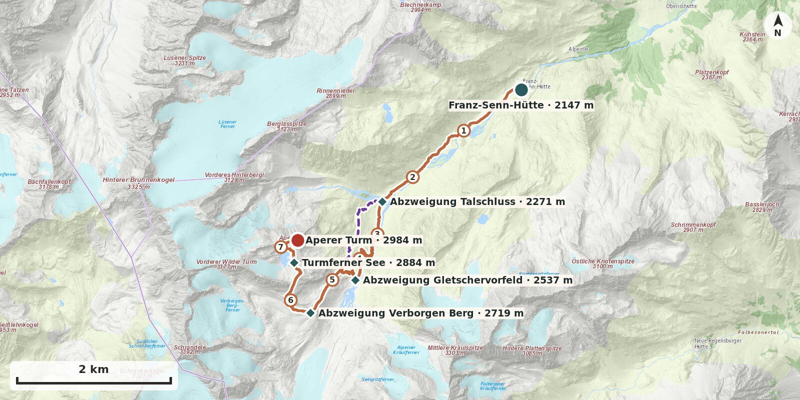
Aperer Turm is one of the most rewarding objectives in the area around the hut. Glacier-free yet surrounded by the glaciers of the Alpeiner Tal, it rises impressively at the head of the valley.
Route description
-
Franz-Senn-Hütte → Abzweigung Talschluss
From the Franz-Senn-Hütte (2147 m), follow the marked path no. 131 towards the Alpeiner Ferner, heading up-valley along the Alpeiner Bach. For a good 2.5 km the route runs almost level across the valley floor; only at the Höllenrachen (c. 2190 m), where the stream squeezes through a short gorge, does the path overcome a small steep step (the via ferrata runs separately through the gorge).
-
Abzweigung Talschluss → Abzweigung Gletschervorfeld
From the signpost, follow the “Gletscherweg” up-valley as it climbs in switchbacks beside the waterfalls of the Alpeiner Bach to the glacier forefield of the Alpeiner Ferner (approx. 2520 m).
-
Abzweigung Gletschervorfeld → Abzweigung Verborgen Berg
From the signpost at the glacier forefield, follow the path up the slopes of the left lateral moraine to its crest. At the signpost there it meets the old approach path. Continue south along the moraine crest to the Verborgen Berg – Aperer Turm junction.
-
Abzweigung Verborgen Berg → Turmferner See
From the fork, the path towards Aperer Turm first climbs gently westwards, then turns north in switchbacks onto a moraine crest. From there, it traverses the hillside and follows a gentle left-hand curve across a bouldery ridge. It then descends gently to the shore of the Turmferner See.
-
Turmferner See → Aperer Turm
Pass the lake and climb the Sonnenhang, following the waymarks to the broad ridge of the Aperer Turm. The final metres to the summit cross lead across a short but slightly exposed, cable-protected notch.
Variants
Variant 1: between Abzweigung Talschluss and Abzweigung Verborgen Berg
From the junction, the path first climbs the moraine slope to the crest of the moraine. In a hollow in the moraine lies a small, idyllic moraine lake. The path then continues uphill southwards until the prominent moraine levels out at about 2650 m. High above the glacier forefield, the path leads to the Verborgen Berg – Aperer Turm junction, from where a path continues into the Berglastal.